


Eden, Twofold Bay and Towamba River Flood Study
The flood study will assist Council and its community to improve future planning for land-use, emergency response and strategic asset management.
What is the study about?
At Bega Valley Shire Council we know some parts of the Local Government Area (LGA) are more prone to flooding than others and we’re committed to finding solutions to reduce the social and economic damages of flooding. With the financial and technical assistance of the State and Commonwealth Government. Council prepared a flood study for Eden, Twofold Bay and parts of the Towamba River.
The flood study developed flood models to represent flooding resulting from catchment rainfall and ocean storms. The key areas included in the study were:
- Impacts of ocean storms on the foreshore and low lying areas around Twofold Bay and Lake Curalo;
- Stormwater and creek flooding in Eden; and
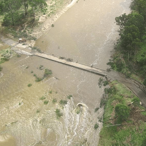
- Flooding from Towamba River and it’s tributaries at Wyndham, New Buildings, Rocky Hall, Burragate, and Towamba.
The computer based flood models were built using digital terrain data to represent the landform of the catchment and creeks as well as bathymetry representing the bed conditions of Twofold Bay and Lake Curalo. Rainfall and ocean conditions from past flood events were used to recreate these events and calibrate the results against historical flood levels observed by the community across the study area.
Why does it flood?
Flooding within the study area can occur for different reasons.
In the upper catchment along the Towamba River and its tributaries, flooding is generally the result of prolonged rainfall causing the rivers and creeks to overtop their banks causing flooding of roads, bridges and private properties.
In the lower lying area of the study area such as Boydtown and the foreshore of Twofold Bay flooding can be caused either by the river flow coming down from the catchment or ocean storms and high tides, often it can be a combination of the two.
In addition, local flooding can be caused by intense short bursts of rainfall. Areas of Eden are known to have experienced flooding where stormwater cannot be contained within the existing pipes and channels.
Why undertake a Flood Study
The preparation of the flood study helps Council to understand existing flooding problems. It also helps to identify where flood management measures may be best implemented to reduce the cost of flooding to the community, assist with emergency management and evacuation processes and guide future development in a way that is compatible with the flood hazard.
Study results
Part 1 - Eden Twofold Bay, Towamba River Flood Study - Final Report - (148 pages) (PDF)
Part 2 - Eden Twofold Bay, Towamba River Flood Study - Maps (PDFs):
- Maps G101 to 304 - Study area and data sources
- Maps G501 to 503 - Study area sub-catchments
- Maps G504 to 511 - Study area subcatchment model extents
- Maps G512 to 517 - Model calibration and community observations
- Maps G601 to 602 - Depth and velocity
- Maps G603 to 606 - Hazard and tidal inundation
- Maps G701 to 704 - Flood planning area and emergency response classifications
Study Timeline
© Bega Valley Shire Council 2024
Our council websites
Contact Us
- 02 6499 2222
- council@begavalley.nsw.gov.au
-
Zingel Place
PO Box 492
Bega NSW 2550 -
Monday to Friday 9.00AM to 4.30PM
Administration building Zingel Place Bega
Australia -
ABN: 26 987 935 332
Was this helpful?